wwerner
-
Gesamte Inhalte
776 -
Benutzer seit
-
Letzter Besuch
-
Tagessiege
15
Inhaltstyp
Forum
Kalender
Profile
Alle Inhalte von wwerner
-
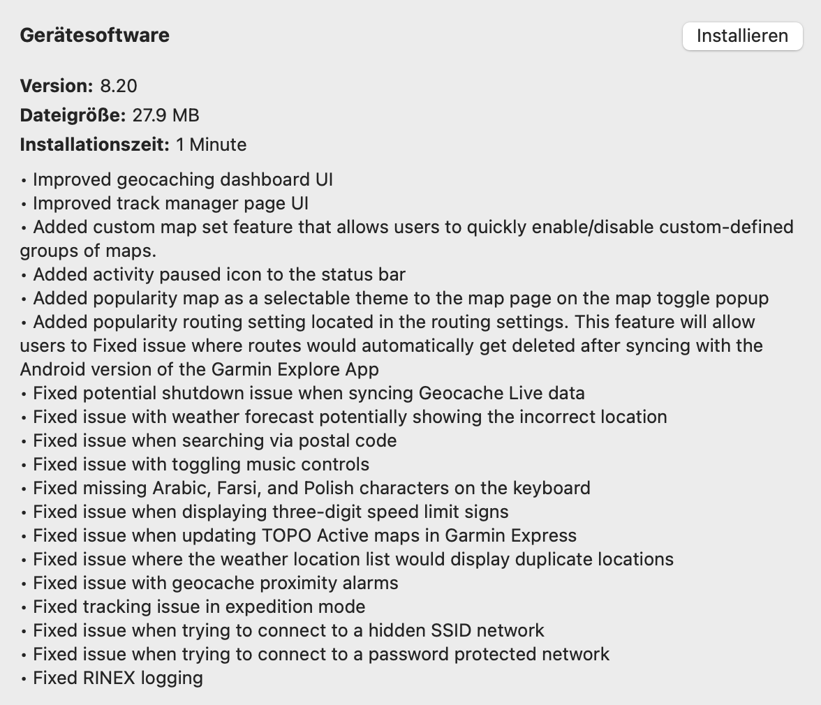
Garmin zeigt mir neue Software 8.5 für das Montana 7X0 auf dem Garmin Express Update Programm. Die Beschreibung der Änderungen ist sehr lang. Leider kann man sie auf Garmin Express nicht herauskopieren. Wenn ich sie irgendwo in vernünftiger Form finde, kopiere ich sie hier ein. Erfahrungen mit der neuen Software fehlen noch. Bin erst am laden. :-) Gruss Werni aka WWERNER
-
Neue Version für das GPSMap66 mit folgenden Änderungen erschienen: Changes made from version 6.00 to 7.20: Fixed possible shutdown when sending a Quick Text from inReach Remote Fixed possible issues with items missing during Explore Sync Fixed an issue where certain submenus could be draws off screen Fixed issue setting custom waypoint offsets using filename Fixed possible issues that casued the main menu to draw over the current page Fixed possible shutdown related to BirdsEye direct downloads Fixed possible issue getting stuck on a page after powerup Fixed possible issues with postal code searches Fixed issue where proximity alerts would only alert once Fixed missing alerts from points loaded using POI loader tool Fixed adding hidden SSID networks Fixed possible issues with time restricted speed limits Fixed navigation to a geocache to always continue until ended by user Fixed geocache file list to wrap Fixed some issues with geocache photos Fixed issue where certain pages could incorrectly appear to have tabs Fixed issue where fit activities could be missing start time data Fixed issue where bearing line would not appear on map in CDI compass mode Improved recent finds list to include navigation started from the map Improved functionality of navigation features with Explore Improved round trip routing setup experience Gruss Werni
-
Beiliegend die Infos über den Change. Darunter auch: "Improved Geocaching Dashboard". Bin gespannt... Gruss WWERNER

-
Änderungen: Version 9.1 (Januari 2021) Neu: - Persönliche Notiz und korrigierte Koordinaten können automatisch auf Geocaching aktualisiert werden, wenn du sie bearbeitest (nur Premium-Nutzer) Verbessert: - Neues Layout für den Info-Tab mit einer klareren Aufteilung von Geocache-Daten und eigenen Wie immer via Mac Application Store zu beziehen. Gruss WWERNER
-
Die Aussage "Das WLAN muss mit GARMIN Express konfiguriert werden" kann so nicht stimmen. Ich kann direkt vom Gerät aus alle WLAN in der Umgebung verbinden. Gruss WWERNER
-
Die neue Version von Basecamp findet sich hier: https://www8.garmin.com/support/download_details.jsp?id=4449 Die neue Version behebt ein Kompatibilitätsproblem mit MacOS 11 Big Sur. Gruss WWERNER
-
Habe das Update auch gemacht. Scheint bei mir problemlos zu laufen. Gruss WWERNER
-
6.4 ist inzwischen als regulärer Update via Garmin Express erhältlich. Gruss WWERNER
-
Garmin hat wieder einmal mit Qualitätssoftware brilliert: Montana 7x0 Firmware Update 6.40 BETA is available for users with unresponsive touchscreens following the Firmware 6.30 update. Change made from version 6.30 to 6.40 BETA: Fixed an issue where touchscreen firmware could fail to load. Firmware will continue to load without needing user input on the next power cycle. Please contact Product Support for assistance installing this update. Additional instructions are provided in the folder 'FOR-USERS-WITH-UNRESPONSIVE-TOUCHSCREEN.'.. There are special instructions for installing this update. Download: Montana 7x0 Firmware Update 6.40 BETA with Special Instructions. Also wartet besser zu mit dem Update für 6.3, bis 6.4 publiziert ist. Wer 6.3 schon geladen hat und Probleme hat, verwendet obigen Link. Gruss WWERNER
-
Change made from version 5.30 to 6.30:• Added wifi icon flash on status page/status bar when wifi on but not connected.• Added custom patterned lines for other road types.• Added the ability to lock/unlock the configurable fields on the corner data fields dashboard.• Added a lock icon on confirmation pages to clarify auto-lock status.• Added configurable fields on the corners of the map page.• Added a "note" option for logging geocaches.• Added the ability for the measure distance function to start at any point.• Added Rain mode to Touch Sensitivity settings.• Improved map drawing times.• Improved filename time formats.• Improved inReach activation prompts.• Improved swiping on the status page.• Fixed issue with lock icon not showing up on secure wifi networks in night mode.• Fixed issue with shutdown when sorting photos by date in photo viewer.• Fixed issue with geocache proximity alarm causing slow start up times with .ggz files loaded.• Fixed issue with slow start up after deleting .ggz files.• Fixed issue with font on corner data fields dashboard in night mode.• Fixed issue with the widget page indicators occasionally blinking on the status page.• Fixed issue with text alignment for inReach messages.• Fixed issue with flashing on the photo viewer.• Fixed issue with potential shutdowns when navigating tracks.• Fixed overlapping icons on the map page with corner data fields dashboard.• Fixed issue with the wifi status not updating.• Fixed issue with "track up" and "north up" map orientations.• Fixed issue with manual route transitions.• Fixed issue with the tabs/status bar flashing on the geocache page.• Fixed issue with zoom levels on round trip routing pages.• Fixed issue with getting a false max number of photos exceeded message.• Fixed issue with Explore sync and map settings.• Fixed issue with CIQ apps and widgets in landscape orientation.• Fixed issue with auto-zoom on the weather map.• Fixed issue with copy-as-reversed fit activity stats.• Fixed issue with truncation of a data field on the trip computer page.• Fixed issue with mounting SD cards formatted on Mac computers.• Fixed possible shutdowns when using Birdseye imagery.• Fixed Express sync errors due to empty current activity file.• Fixed "off road" label for routes that were not off road.• Fixed issues with geocaches not showing up when attempting to program a chirp.• Fixed issues with truncated translations.• Fixed issue with overlapping text in the geocache info box.• Fixed issue with the "Go" button not appearing on some routes.• Fixed issue with geocache filters turning back on automatically.• Fixed a potential for a shutdown on the map page.• Fixed issue with adding via points. Freiwillige vor. Gruss WWERNER
-
- 1
-

-
Und jetzt ist auch noch der neue Release von BaseCamp for Mac 4.8.10 veröffentlicht worden. Auch hier keine nennenswerten Änderungen ( "Various stability and bug fixes"). Gruss WWERNER
-
Garmin hat einige Tools für den Mac erneuert (alles kleine Updates mit "Stability" Verbesserungen: Garmin has posted MapInstall and MapManager for the Mac software version 4.3.4. Garmin has posted WebUpdater for Mac software version 2.2.1. Garmin has posted POI Loader for Mac software version 2.4.2.
-
Auf einer Blog Seite zum Garmin GPSMAP66 von http://www.gpsrchive.com habe ich folgende Information gefunden: Und weiter: Im Klartext heisst das, dass Daten von Caches, die manuell auf ein Gerät geladen werden, durch einen Live Download auf dem Gerät selbst weder aktualisiert noch überschrieben werden. Was ich eigentlich erwartet hatte (natürlich ohne user spezifische Information wie korrigierte Koordinaten). Konkret: Ich lade jeweils Caches von wichtigen Orten, die ich besuchen werde, vor den Ferien auf mein Gerät (mittels Pocket Queries). Vor Ort brauchte ich jeweils GCLive in der Meinung, dass ich damit neue Caches lade und bestehende aktualisiere (beispielsweise inaktivierte Caches entsprechend ausblende oder neue Logs anzeigen kann). Das ist aber nicht so. Die neuen Caches, die ich zuvor nicht auf das Gerät geladen hatte, werden hinzugefügt. Ein Cache, der vorher geladen wurde und damals aktiv war, wird aber nicht auf inaktiv oder archiviert geändert. Man muss sich also entscheiden, ob man generell mit vorgeladenen Caches arbeitet (beispielsweise an Orten, wo man vermutlich keine WLAN und keine Mobile Daten Connection hat), oder ob man mit GCLive Daten arbeiten will (Städten). Wenn man mit GCLive Daten arbeitet und irgendwas geht schief mit der Verbindung Groundpeak - Mobile Phone - Garmin hat man dann halt Pech gehabt. Nicht, was ich selbst erwartet hätte.... Gruss WWERNER
-
GPSMAP 66: Firmwareversion 4.7
wwerner antwortete auf Paravan's Thema in Garmin GPSMAP 67/66/64/62 -Serie
Wie es auf dem Montana 700 leider funktioniert: Beim Filtern werden nur die Caches ausgeblendet, aber nicht die zusätzlichen Wegpunkte. Die werden immer angezeigt, auch wenn der Cache selbst herausgefiltert wird. Das macht den Screen etwas unübersichtlich... Kann jemand, der den Update schon geladen hat, das verifizieren für das GPSMap66? Gruss WWERNER -
Montana 7x0 Firmware Update 5.30 is available via Garmin Express or Wi-Fi direct as of 12SEP20.Change Log (from Garmin Express):• Disabled USB DMA to avoid mass storage corruption.• Added persistence of Units settings within profiles.• Improved map movement when auto zooming and moving while navigating.• Fixed various translation issues.• Fixed issue with map drag when starting drag in a dashboard.• Fixed issues with hourly temperature display in Active Weather.• Fixed issues with position format setting string precision.• Fixed issue with geocache log length restriction in keyboard.• Fixed issue with display of ETE data fields on trip computer.• Fixed issue with "send" button when programming a chirp and sending a geocache.• Fixed potential time zone issue when selecting a day in the Calendar.• Fixed issue with Explore Waypoints having incorrect times.• Fixed issue with night time speed limits showing incorrectly.• Fixed issue where destination would incorrectly change if switching routing calculation method while direct routing.• Fixed issue where invalid characters were being allowed in Activity names.• Fixed issue with Bluetooth pairing for some iPhone models.We suspect some unpublished changes may also be included in this update.Please report your observations here after installing and testing! Gruss WWERNER
-
Version 8.5 (September 2020) Neu: - Laden Sie Ihre Log-Entwürfe herunter und stellen Sie sie in iCaching fertig. Dies macht iCaching zum perfekten Begleiter, wenn Sie die Geocaching-App für Geocaching verwenden. - Die neuen Geocache-Attribute wurden hinzugefügt: Bonus-Cache, Powertrail, Challenge-Cache und Lösungsprüfer Verbessert: - iCaching kann jetzt wieder Waymark LOC-Dateien importieren. Behoben: - Mehrere kleine Fehler sind behoben Wie immer über den App Store. Gruss WWERNER
-
Ja. Habe zwei Karten geladen. Funktioniert und sieht sehr schön aus. Gruss Werni.
-
Natürlich. Inzwischen habe ich noch etwas anderes probiert. Ich benütze normalerweise die OSM Maps von www.frikart.no. Ich mag das Kartenbild und hatte nie Probleme auf Oregon 700 und auf GPSMAP66. Aber das Montana 700 erkennt sie nicht. Nun habe ich noch einen Versuch mit den Karten von http://garmin.openstreetmap.nl gemacht. Und die kann das Gerät nun wie gewohnt erkennen. Das Problem mit den OSM Karten hat also nicht mit der SD Card zu tun, sondern mit der spezifischen Version der OSM Map. Bin gespannt, ob die das noch fixen... Gruss WWERNER
-
Hallo zusammen. Ich habe also heute eine neue, frische Micro SD Card gekauft. Leider mit dem gleichen Resultat. Die GARMIN Karte (Auto City Navigator) wird erkannt, die OSM Karten nicht. Bin gespannt, ob das jemand mit seinem Montana 700 verifizieren kann. Es könnte ja auch ein Gerätefehler sein. Gruss WWERNER
-
Hallo zusammen Mein Montana 700 ist am Freitag geliefert worden. Erster Eindruck: - sehr, sehr schnell (aufstauten, Suche, Karten scrolling, etc.) - super Bildschirm (nahe am Handy Niveau) - bis jetzt konnte ich keine Fehler finden (Garmin scheint doch noch Fortschritte zu machen...) - GROSS. Wenn das in die Hosentasche soll, müssen die Hosen gross sein. Probleme: - OSM Karten auf der SD Card werden nicht erkannt. Ich kann aber nicht ausschliessen, dass es sich um ein SD Karten Problem handelt.Ich beschaffe mir noch eine andere Karte, um das zu verifizieren. Gruss WWERNER
-
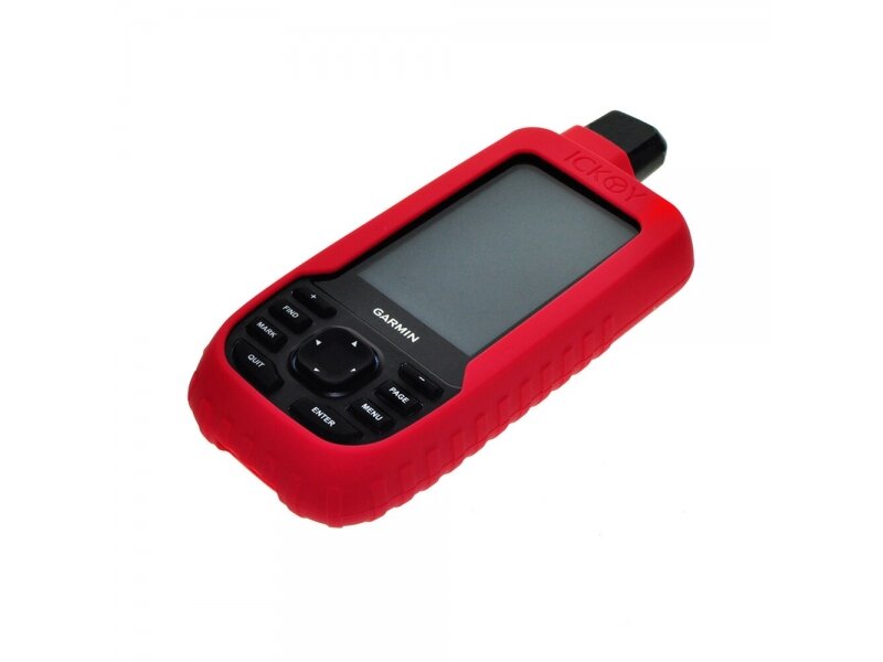
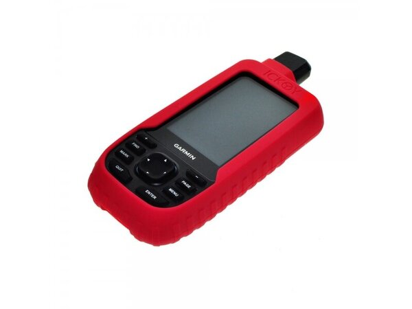
Einverstanden, der Bildschirm beim Montana 700 könnte exponierter sein als bei anderen Geräten. Allerdings scheint Garmin hier erstmals (?) Gorilla Glas verwendet zu haben, das auch bei vielen Mobile Phones einen guten Dienst tut. Vielleicht wird der Zubehörmarkt auch eine Lösung gegen diese Ängste anbieten. Siehe angehängtes Foto eines Gummimantels für das GPSMap 66, das eigentlich das gleiche Problem (aber kein Gorilla Glas) hat. Gruss WWERNER
-
Und schon ist der erste Release für die neuen Montana 7XX veröffentlicht. Changes made from version 3.10 to 4.20: Added Collections Manager. Added confirmation prompt to 'Reposition Here' for a waypoint in waypoint manager. Added red led blink when battery is low. Added page indicator to trip computer when trip computer has more than one page of data fields. Added support for the additional waypoints part of a geocache to be downloaded via geocaching live. Added geocache proximity alerts. Added battery percentage to the status bar. Improved birdseye download speed and speed estimates. Improved inReach contact selection indication. Improved keyboard to auto-shift after newline is entered. Improved ability to touch north arrow on map. Improved mark waypoint page. Fixed various translation issues. Fixed page flow issue after exiting wifi page after having accessed it via the status page. Fixed issue with 'View Map' from the route planner elevation plot. Fixed issue causing duplicate birdseye downloads to show up in the birdseye list. Fixed issues with automatic wifi toggling on flashlight page. Fixed issue with map zoom level resetting after having accessed active weather from the status page. Fixed geocache name and icon overlap in geocache dashboard. Fixed tide chart UI issues. Fixed issue where power button would initiate navigation when viewing Chirp information. Fixed label centering on keyboard. Fixed issues with photo viewer. Das dürfte dann der Release sein, mit dem die Geräte initial auf dem Markt erscheinen... Gruss WWERNER
-
Die verschiedenen Quellen (Garmin EU Shop, Garmin US Shop, Garmin Pressemitteilung, Berichte im Web und YouTube, verschiedene Vertriebsquellen) zeichnen ein etwas verworrenes Bild bezüglich der Ausstattung der drei Montana Geräte. Es sieht so aus, als ob folgende Aufstellung gültig sein könnte: Garmin Montana 700 - Keine inReach Funktion - Gerät kann mit der aufladbaren Batterie oder optional mit einem Batteriehalter für drei AA Batterien betrieben werden (separat zu beschaffen) - keine Anschlussmöglichkeit für externe Antenne - Topo Active Map - keine Kamera Garmin Montana 700i - inReach Funktion - nur Betrieb mit aufladbarer Batterie, aber nicht mit AA Batteriehalter (Grund unklar) - Anschluss für externe Antenne vorhanden - Topo Active Map Europe (oder USA) und City Navigator Map (Auto) Europe (oder North America) - keine Kamera Garmin Montana 750i - wie 700i aber zusätzlich mit Kamera Das ist der gegenwärtige Stand meiner Recherchen. Bin aber nicht sicher, ob sie richtig sind. Garmin Europa hat zum Beispiel nur im Presse Material aber nicht im Shop auf die City Navigator Karte hingewiesen. Gruss WWERNER
-
Paravan hat es auch schon im Angebot...
-
Guckst Du hier: https://gpsradler.de/news/garmin-montana-700-vorstellung-kurztest/ Gruss WWERNER